Chinese nurse’s first aid to Japanese student goes viral

Chinese nurse's response to sick Japanese student goes viral

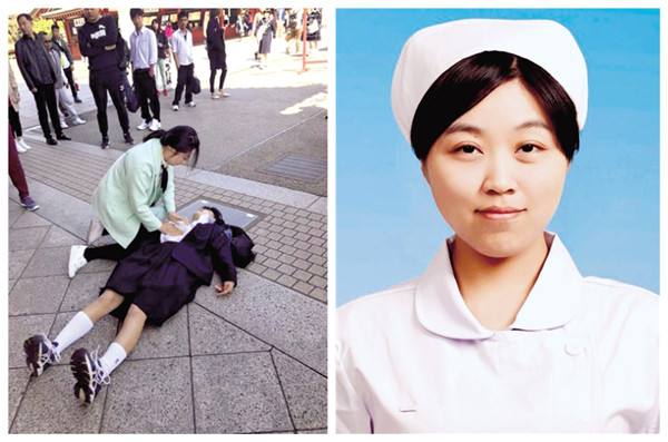
Chinese nurse Ren Shuangshuang. [Photo/Zhengzhou Evening News]

A post about a Chinese nurse who helped a Japanese student has gone viral on Weibo, a Twitter-like social media platform.

During a vacation in Japan, the 28-year-old nurse rushed to aid a Japanese middle-school student who was having an epileptic seizure on April 18, according to media reports.

Ren Shuangshuang works at Henan Cancer Hospital as a surgical nurse. She encountered the Japanese girl when visiting the famous tourist attraction Senso-ji.

“It was very crowded and a girl fainted,” Ren recalled. She immediately approached the girl after the translator for her tour group cried out for help. The girl was twitching and foam was coming out of her mouth. Ren immediately guessed that the girl was having an epileptic seizure.

Ren lay the girl down, unbuttoned her coat and cleaned the foam from around her mouth. She stuffed a wet tissue into the girl’s mouth to prevent her from accidentally biting her tongue. The girl eventually regained awareness and tried to sit up to thank Ren, but the nurse told her to lie back down and rest. An ambulance later arrived to transport the girl to a hospital.

Ren’s actions were recorded by other tourists and uploaded to social media. Her good deed has been widely lauded.

So far, the post has got more than 12,000 comments and nearly 200,000 thumbs-up. “Good girl! That’s what a doctor with good virtues would do. Love has no nationalities,” said one of the comments, which received more than 16,000 thumbs-up.


Star UAV to monitor forest fire

A CH-4 UAV takes off from a regional airport in the Greater Khingan Mountains for forest monitoring on May 10. [Photo provided to China.org.cn]

A CH-4 unmanned aerial vehicle (UAV), also known as a “rainbow drone,” was deployed recently in northeast China’s Greater Khingan Mountains to provide an “eye in the sky” for possible forest fires.

Its deployment followed pressing demands from local forestry authorities for an advanced form of forest monitoring and to provide an early warning in case of fire. It coincided with the 30th anniversary of a major fire in the Greater Khingan Mountains, on May 6, 1987.

Monitoring and surveillance to spot forest fires in the region were traditionally conducted by forest keepers’ visual observation from fixed look-out posts and, occasionally, from a manned aircraft.

Although quite effective, such methods were far from efficient enough and involved too much manpower, said Wu Pengchao, chief of the Tahe Aviation Station in the mountains.

By contrast, a fixed-wing UAV like the CH-4 is a far better solution. Its service ceiling is 7,200 meters. In normal operation, it can hover at an altitude of 4,000 – 5,000 meters and stay airborne for up to 40 hours, meaning one sortie can provide constant surveillance for almost two days during which time ground staff can take a rest in shifts.

The CH-4 is equipped with both visual and infrared sensors to allow it to see day and night.

In particular, its near-infrared sensors allow CH-4 to see through dense smoke and pinpoint the source of any fire, according to Zhou Nai’en, deputy general manager of CH UAV Company, which is affiliated to the China Academy of Aerospace Aerodynamics (CAAA).

“This is something human eyes can never achieve, no matter how many manned planes are mounted,” said Zhou, noting that traditional aerial observation for forest fire was conducted by people looking out through the plane’s portholes with binoculars.

The Tahe aviation station chief said the introduction of the UAV also followed the call from State Forestry Administration to enhance and innovate forest monitoring; the station chose CH-4 out of other homebuilt UAVs because of its superb performance over affordable price.

Forest surveillance is the latest mission to add to the list of civil tasks of rainbow drones whose good performance in overseas anti-terrorism operations has earned them fame as “star UAVs.”

Zhou, a designer for rainbow series drones, maintained that a UAV was a basic platform with the payload deciding whether its mission is military or civil.

Domestically, different types of rainbow drones have shown their strengths in geological exploration and exploitation, disaster area observation and regional communications enhancement. Their roles will soon be expanded to maritime surveillance, according to Zhou.


Explanatory document issued on Belt and Road Initiative

China issued a detailed explanatory document on the Belt and Road Initiative on Wednesday.

The document, titled Jointly Build the Belt and Road: Ideas, Practices and Chinese Contributions, was released by the Leading Group on the Construction of the Belt and Road.

The Belt and Road Initiative is a China-proposed trade and infrastructure plan connecting Asia with Europe and Africa.

The document aims to promote understanding of the initiative, demonstrate the achievements, and enhance strategic mutual trust, dialogue and cooperation among nations, so as to contribute to the building of a community of common destiny, said the introduction to the document.

In addition to an introduction and conclusion, the document comprises five chapters on the initiative’s blueprint, cooperation framework, spheres and mechanisms, and forecast on future cooperation.

China will host the Belt and Road Forum for International Cooperation on May 14 and 15.


8 dead, 11 injured in Xinjiang earthquake

Residents receive treatment at Kuzigun Village in Taxkorgan County, northwest China’s Xinjiang Uygur Autonomous Region, May 11, 2017. [Photo/Xinhua]

Eight people have been confirmed dead and 11 others were injured after a 5.5-magnitude earthquake jolted Taxkorgan County in northwest China’s Xinjiang Uygur Autonomous Region at 5:58 a.m. Thursday.

Witnesses said frequent tremors have been felt after the quake.

The search and rescue work is underway.

The injured people have been sent to hospital for treatment.

The epicenter, with a depth of about 8.0 km, was monitored at 37.58 degrees north latitude and 75.25 degrees east longitude in the southeast part of the Pamir Plateau.

Taxkorgan, some 1,250 kilometers from Urumqi, capital of the region, borders Pakistan, Afghanistan and Tajikistan.


China issues regulation on military legislation

President Xi Jinping, who is also chairman of the Central Military Commission, has signed a decree that will release a regulation on military legislation.

The regulation, which took effect Monday, defines the rules for establishing military laws and regulations as well as the drafting of standard documents.

The regulation standardizes the formulation of military laws and regulations, spanning the drafting, submission, modification and issuance stages.

In addition, it regulates the review and compilation of records, and suggests measures to improve the management system for documents.