|
|
|
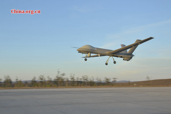
A CH-4 UAV takes off from a regional airport in the Greater Khingan Mountains for forest monitoring on May 10. [Photo provided to China.org.cn]
|
A CH-4 unmanned aerial vehicle (UAV), also known as a “rainbow drone,” was deployed recently in northeast China’s Greater Khingan Mountains to provide an “eye in the sky” for possible forest fires.
Its deployment followed pressing demands from local forestry authorities for an advanced form of forest monitoring and to provide an early warning in case of fire. It coincided with the 30th anniversary of a major fire in the Greater Khingan Mountains, on May 6, 1987.
Monitoring and surveillance to spot forest fires in the region were traditionally conducted by forest keepers’ visual observation from fixed look-out posts and, occasionally, from a manned aircraft.
Although quite effective, such methods were far from efficient enough and involved too much manpower, said Wu Pengchao, chief of the Tahe Aviation Station in the mountains.
By contrast, a fixed-wing UAV like the CH-4 is a far better solution. Its service ceiling is 7,200 meters. In normal operation, it can hover at an altitude of 4,000 – 5,000 meters and stay airborne for up to 40 hours, meaning one sortie can provide constant surveillance for almost two days during which time ground staff can take a rest in shifts.
The CH-4 is equipped with both visual and infrared sensors to allow it to see day and night.
In particular, its near-infrared sensors allow CH-4 to see through dense smoke and pinpoint the source of any fire, according to Zhou Nai’en, deputy general manager of CH UAV Company, which is affiliated to the China Academy of Aerospace Aerodynamics (CAAA).
“This is something human eyes can never achieve, no matter how many manned planes are mounted,” said Zhou, noting that traditional aerial observation for forest fire was conducted by people looking out through the plane’s portholes with binoculars.
The Tahe aviation station chief said the introduction of the UAV also followed the call from State Forestry Administration to enhance and innovate forest monitoring; the station chose CH-4 out of other homebuilt UAVs because of its superb performance over affordable price.
Forest surveillance is the latest mission to add to the list of civil tasks of rainbow drones whose good performance in overseas anti-terrorism operations has earned them fame as “star UAVs.”
Zhou, a designer for rainbow series drones, maintained that a UAV was a basic platform with the payload deciding whether its mission is military or civil.
Domestically, different types of rainbow drones have shown their strengths in geological exploration and exploitation, disaster area observation and regional communications enhancement. Their roles will soon be expanded to maritime surveillance, according to Zhou.
read more