Sandstorms sweep through northern China
|
|
|
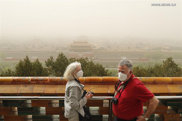
Tourists in mask visit Wanchun Pavilion in Jingshan Park in Beijing, capital of China, May 4, 2017. [Photo/Xinhua] |
A sandstorm swept over much of north China including Beijing on Thursday, turning the sky yellow and reducing visibility.
The National Meteorological Center (NMC) continued its blue alert for sandstorms on Thursday evening, forecasting windy and dusty weather in north China for the next three days.
Since Wednesday, northern areas have witnessed the most severe sandstorms this year, affecting more than 10 provincial-level regions, including Beijing, Inner Mongolia and Xinjiang, and covering an area of 1.63 million square kilometers, NMC data showed.
Weather forecasting authorities in Beijing issued a yellow alert for strong winds at 4:35 p.m., predicting wind speeds of up to 80 km per hour on Friday.
Most monitoring stations in the southwestern part of Beijing showed PM10 readings of more than 2,000 micrograms per cubic meter of air at 8 a.m. Thursday, according to data from Beijing Municipal Environmental Monitoring Center.
Visibility across the city was as low as two kilometers, and the air pollution has been dragged to Level VI, the highest.
According to the Beijing Times, more than 40 flights at Beijing Capital International Airport were delayed, with another 15 canceled.
Neighboring Tianjin Municipality was also hit by dust and sand, which darkened the sky and affected traffic flow.
“The sky turned gray and the smell of dust and sand crept into my room this morning. My child complained about feeling uncomfortable after playing outside,” said a Tianjin resident surnamed Liu.
Traffic authorities have advised drivers to reduce their speed and to use their fog lights.
According to Lu Huanzhen with Tianjin meteorological station, the sandstorm in Tianjin should be over by Friday night.
Sandstorms were also reported in north China’s Hebei Province and are expected to clear from Friday.
Zhu Jiang, head of the Institute of Atmospheric Physics of the Chinese Academy of Sciences, said the sand had traveled from Gansu, Inner Mongolia and Ningxia, as well as Mongolia.
Ejin Banner of Alxa League in Inner Mongolia saw the first sandstorm on Wednesday, with visibility reduced to less than 100 meters.
Strong winds reduced temperatures in the region by about four degrees Celsius. Local weather stations warned residents to keep their doors and windows closed, to buttress sheds and billboards, avoid riding bicycles and to remain alert for forest fires.
China has a four-tier color-coded system for severe weather, with red being the most serious, followed by orange, yellow and blue.
It is the first sandstorm across China this year, later and less frequent than previous years, considering at least two rounds of sandstorms had been recorded every May in past years.
Data showed the annual number of sandy days in Beijing decreased from 26 days at most in the 1950s to around three days after 2010.
Zhang Bihui, a senior engineer with the NMC environmental meteorological center, said the lower sandstorm frequency is attributed to climate change bringing weaker and less-frequent cold fronts and China’s forestation efforts.
Zhang also said forests could only stop part of sand moving near the ground level, and the sand this time were actually blown to Beijing at a height of around 5,000 meters.
Sandy weather in Beijing is expected to end on Friday evening, but similar weather may be seen on Saturday and Sunday in China’s southern regions.
