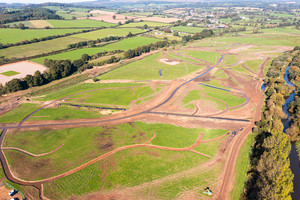
Northern creek network at Lower Otter site nearly complete

The northern creek network
- Northern creek network largely finished
- Channels are reconnecting to historic floodplain
- The work is creating new wildlife habitats
Excavation of the network at the northern end of the site – north of South Farm Road – is now largely completed. Next spring, creeks will be excavated in the south of the site, connecting to the north under the new South Farm Road bridge.
Together, the total excavated length of the creek network already exceeds 3 kilometres. These will evolve naturally over time once connected to the Otter. One of the islands on the floodplain is also nearing completion, this will act as a refuge for birds at high tide.
Dan Boswell, Environment Agency project manager for the site, said:
When the creeks are all complete we will have a network that will reconnect the estuary to its historic floodplain.
The creeks will be the ‘veins’ of the estuary, bringing new life to the valley floor, attracting a wide variety of wildlife to the wetland habitat and enabling floodwater to drain down more quickly.
The Lower Otter Restoration Project is part of the €26 million Promoting Adaptation to Changing Coasts (PACCo) project, which also has a similar scheme underway in the Saâne Valley in Normandy, France.
In Devon it will see current grassland created during historic reclamation work replaced with 55 hectares of intertidal mudflat and saltmarsh, plus almost 3 hectares of broadleaved woodland and 1.5 kilometres of hedgerow.
Notes to editors
The French arm of the project, Basse Saâne 2050, is in the Saâne Valley in Normandy and includes building a new water treatment works and moving a campsite at Quiberville.
It is thought that up to 70 estuarine sites in northern France and southern England may benefit from the PACCo project, by following the model being used on the Lower Otter and Saâne Valley.