Press release: Call for feedback on next section of £45m York Flood Alleviation Scheme

The Environment Agency has released further details for three sections of its £45m York Flood Alleviation Scheme and is holding a public drop-in to give information and get feedback on proposals.

As well as the work the Environment Agency is doing on the Clementhorpe, New Walk and North Street sections of the £45m York Flood Alleviation Scheme, and the River Foss catchment, the Agency is developing plans for the sections that run from York Ring Road at Rawcliffe to Lendal Bridge.

This stretch is split into three sections: the ring road to Clifton Bridge; then to Scarborough Bridge; and then to Lendal Bridge.

Clifton Bridge to Scarborough Bridge

Environment Agency project manager for the work, Richard Lever, said:

The middle section of the three, Clifton Bridge to Scarborough Bridge, will be the area we will progress flood defence works first.

We are holding a drop-in so the public can view plans and give feedback on the proposals that will better protect 150 properties, the majority of which are on Almery Terrace, Sycamore Terrace, Longfield Terrace and Bootham Terrace.

Options include raising the existing flood wall at Almery Terrace and the embankment at the back of the schools’ playing fields, as well as extending the embankment.

Plans also include upgrading the pumping capacity at Burdyke pumping station, which is situated in the middle of the open area between the two bridges. The dike is culverted from near Clifton Backies to where it enters the Ouse.

The drop in will take place at the Environment Agency’s community hub on Wellington Row from 12-7pm on Wednesday (20 June).

The proposals will remain on display for a further four weeks for members of the public to provide feedback.

Ring Road to Clifton Bridge

Mr Lever said:

The section from the ring road to Clifton Bridge will be a major part of the project, better protecting 140 homes, and include raising the embankment and increasing the embankment length towards the Park & Ride, and to behind the Homestead and the YHA.

We are also investigating building a pumping station on Blue Beck, which runs into the Ouse.

We recognise that Clifton Ings and Rawcliffe Meadows are a widely used and much loved public amenity, as well as being a Site of Special Scientific Interest and includes important grasslands, the tansy beetle, bats and newts.

We are currently involved in discussions with key partners, including Natural England, Sustrans and Friends of Rawcliffe Meadows, in how we can minimise the impact on the habitat, cause the least inconvenience while work is being undertaken and maintain amenities when work is complete.

Dependent on these discussions, we are aiming to submit the planning permission for this section before the end of the year.

Scarborough Bridge to Lendal Bridge

Mr Lever said:

For the Scarborough Bridge to Lendal Bridge section we are working with partners, including Historic England, on options for flood defence improvements in Museum Gardens, which help better protect homes in the Marygate area.

This includes raising the current embankment at the bottom of Museum Gardens or looking at a flood wall running up the Marygate side of the gardens.

We are also investigating the best way to raise and improve the flood gate at the bottom of Marygate.


Press release: Edward Donovan nearly jailed for trashing Devon countryside

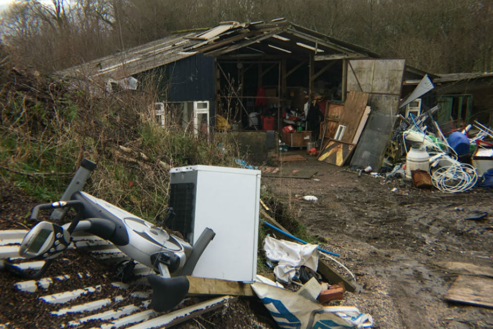
A waste removal businessman who blighted Devon countryside with 2,000 tons of rubbish – then set fire to it – has narrowly avoided jail.

The Environment Agency prosecuted Edward Donovan, of Churchill Drive, Crediton, for a range of offences after he turned part of an elderly land owners’ farm at Spreyton into an illegal waste site. It was here he dumped waste he collected from commercial businesses across central and east Devon as EDS (Ed Donovan Services).

Donovan pleaded guilty to charges under the Environmental Protection Act at Exeter Magistrates Court, which included running a waste site on land owned by a couple in their 70s without a permit, causing pollution and setting fire to waste. He was given a jail sentence of 18 weeks, suspended for 2 years, and banned from the waste trade for 5 years.

He was also ordered to pay Devon & Somerset Fire & Rescue Service £1,232 – the amount it cost the service to attend a large waste fire he set at the location last year. Donovan also has to pay £4,252 costs to the Environment Agency.

Different angle of the building overflowing with rubbish
The officer in charge of the case said it was one of the worst illegal waste sites he had encountered

Adrian Evans, of the Environment Agency, said:

This is one of the worst incidents of illegal waste management I have come across for some time.

The defendant showed a complete disregard for the environment, health and safety and for the owners of the land and their neighbours.

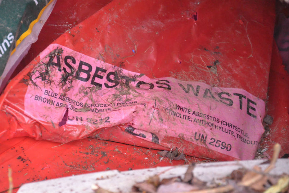
As well as furniture, plastics, plasterboard and other vast quantities of waste which were strewn across a large area, we found materials containing asbestos.

The land owners were unaware of Donovan’s activity, who had been allowed to use the site from May 2017 in lieu of payment for dismantling and removing 3 caravans. When they found out, they were horrified and their son told Donovan to tidy up the site in November 2017. Instead, the defendant set waste alight.

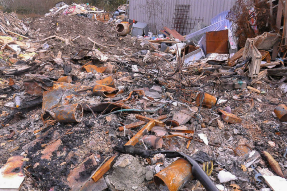
Lots of burnt rubbish and ash on the ground
When told to clear the site, Donovan instead set a fire which had to be put out by the fire service

Adrian Evans, of the Environment Agency, said:

This case serves as an important reminder to businesses and the public to be vigilant about who they allow to remove their waste.

Waste producers should always insist on seeing evidence that waste being removed will be taken to suitably licensed or exempt facilities to be properly disposed of or recycled.

Close-up of red plastic waste bag with asbestos written on it
Asbestos was amongst waste dumped

The Environment Agency has some simple steps for all householders and businesses to think about when giving your waste items to someone else to dispose of, whether you have paid them or not:

  • Check they are a registered waste carrier. Ideally they should have a copy of their registration documents on them, ask to see these. You can check their licence number at environment.data.gov.uk/public-register, or call 03708 506506 and we can check for you.
  • Get a written receipt/transfer note showing their contact details, a description of your waste and details of where they are taking it.
  • Note down the make, colour and registration number of the vehicle that’s taking your waste away.
  • If their quote seems too good to be true, it probably is. Get another quote for comparison.

Taking these steps will help us all work together to deter waste criminals and reduce illegal fly-tipping and dumping that blights communities and costs thousands of pounds to clear and make safe.

Note to Editor:

Donovan pleaded guilty and received an 18-week prison sentence, suspended for 2 years, for each of the following offences, to be served consecutively:

  1. Regulation 12(1)(a) & 38(1)(a)&(b) Environmental Permitting Regulations 2010:
    ‘Operate a Regulated Facility (or knowingly cause or knowingly permit) except under and to the extent authorised by an environmental permit’.

  2. Section 33(1)(a) Environmental Protection Act 1990:
    ‘Deposit or knowingly cause or knowingly permit the deposit of controlled waste on land without the benefit of an Environmental Permit authorising the deposit’.

  3. Section 33(1)(b) Environmental Protection Act 1990:
    Submit controlled waste (by burning), or knowingly cause or knowingly permit ‘controlled waste to be submitted, to any listed operation that is not carried out under and in accordance with an environmental permit’.

  4. Section 33(1)(c) Environmental Protection Act 1990:
    ‘Treat Keep or dispose of controlled waste in a manner likely to cause pollution of the environmental or harm to human health’.

  5. Section 34(6) Environmental Protection Act 1990:
    Failure to ensure a waste transfer note (required by the Environment Protection (Duty of Care) Regulations 1991) was completed and signed on the transfer of waste.

Donovan was also given a 5-year Criminal Behaviour Order preventing him from working in the waste industry.


Press release: Vital part of Mytholmroyd flood defence scheme gets green light

Plans to construct flood walls at an industrial estate in Mytholmroyd to provide better protection for both businesses and residents have been approved by Calderdale Flood Recovery and Resilience Partnership Board.

They have given the go ahead for walled defences at Greenhill Industrial Estate as part of the £30m Mytholmroyd Flood Alleviation Scheme which will substantially increase the standard of protection for local businesses, including Vale Upholstery and the whole village.

Members of the board were updated at their meeting on 15th June about the investigations into a range of options for the Greenhill site including widening the channel and constructing different types of walls.
Approval was given to build concrete walls on both the right and left banks, install flood gates at each end of the bridge and remove security fencing which obstructs the flow of the river.

This option was recommended as providing the best standard of protection for the whole village, within the resources available and timescales of the current construction programme. However, it was also agreed by the board to continue to seek opportunities to carry out widening the channel at Greenhill Industrial Estate in the future, as well as other measures such as reservoir management and natural flood management.

The scheme, with walled defences at Greenhill Industrial Estate will provide a one in 50 year standard of protection (two percent chance of flooding occurring in any given year) for 400 homes and businesses in the village. This is a substantial increase from the current one in 5 years standard of protection (20 percent chance of flooding).

Helen Batt, Calder catchment director for the Environment Agency said:

We are committed to providing the best possible protection to the Mytholmroyd community as quickly as we can within the funds we have available.

The Greenhill industrial estate is an essential part of the flood defence scheme and we have developed our plans in consultation with local businesses at that site.

We will progress with the next phase of the Mytholmroyd Flood Alleviation Scheme without delay – but continue to explore funding opportunities for further ways to improve the protection for people living and working in the village and the rest of the Calder Valley from flooding in the future.

Cllr Tim Swift, Leader of Calderdale Council and Chair of the Calderdale Flood Recovery and Resilience Partnership Board said:

We are committed to protecting communities like Mytholmroyd to help them thrive so that people want to live, work, visit and invest there.

Given Mytholmroyd’s vulnerability to flooding and the damage caused by recent incidents, it was important to find a solution that would enable the works to continue in a timely way and provide a high standard of protection until further potential works can be progressed.

The approved option will ensure the best possible use of our resources, enabling us to continue to approach funding bodies without delaying this essential scheme and putting residents and businesses at unnecessary risk.

Plans for the Mytholmroyd flood defence scheme have been developed by the Environment Agency in partnership with Calderdale Council. It is expected to be completed Winter 2019 / 2020. Design and construction of the scheme is being carried out by main contractor VBA, a joint venture comprising VolkerStevin, Boskalis Westminster and SNC-Lavalin’s Atkins business.

Vital works to be completed as part of the scheme include construction of new, raised and improved flood walls, the relocation of Caldene Bridge, widening of the river channel at Caldene Bridge and on the right bank in front of St Michael’s Church and flood proofing of the buildings next to the river. Work will also be carried out to reduce flooding from the canal, culverts and Burnley Road.

For the latest news about the scheme, sign up for regular news bulletins by emailing: mytholmroydFAS@environment-agency.gov.uk. You can also follow #MytholmroydFAS @EnvAgencyYNE on Twitter or visit https://www.eyeoncalderdale.com

The Environment Agency is investing £475m in Yorkshire to better protect 66,000 homes across the county as part of our current six year programme to 2021.


Press release: Opportunity to shape plans to reduce flood risk in Otley

Following the creation of a digital model of the river, and testing options in the model, a team from Leeds City Council, Environment Agency, and consultants WSP have now come up with four options that they would like the community’s views on.

Residents and business owners can come and talk to the team at:

  • The Core Otley, Unit 11 Orchard Gate, Otley LS21 3NX on Thursday 21 June between 4–7pm

The shortlist of options and supplementary works on show include using flood defence walls, flood defence embankments, maintenance including vegetation clearance and riverbank realignment.

Otley suffered flooding on three occasions between November and December 2015, which saw 74 properties affected. In the Autumn Statement 2016, Government announced £2 million to invest in a scheme to reduce the risk of flooding to homes and businesses.

The scheme is being led by Leeds City Council working closely with the Environment Agency.

Leader of Leeds City Council Councillor Judith Blake said:

We are very pleased to now share with people the progress we and the Environment Agency have made on the plans for flood prevention measures for Otley with these shortlisted options we are now considering and developing further. These measures are all deliverable and would make a real difference in providing reassurance to local residents and businesses against the threat posed by flooding, so we would encourage as many people as possible to come and see what we have in mind and tell us what they think.

John Woods, flood risk management advisor at the Environment Agency said:

After much work we are now approaching a really crucial stage in the project to select a final option for Otley. We’d encourage anyone with an interest in the scheme to look at the potential options and come along to discuss their views with the team. Residents views are really important in helping us to reach a preferred option for the town.

Catchment-wide approach

The Otley Flood Alleviation Scheme is one of several schemes that is adopting a catchment-wide approach. This means the entire River Wharfe catchment area is being considered to help reduce flood risk. This approach looks at a combination of natural processes and engineered options to help slow the flow and catch water further up the catchment so that flood peaks are reduced further downstream.

After the drop-in event, a preferred option will be chosen and developed into the outline design phase, where the community will get another chance to comment on the proposals.

The team is aiming to submit a planning application in winter 2018 and subject to planning approval, construction on site will start by autumn 2019.

For those who can’t make it to the drop-in, the shortlist of options are also available to view online here and if anyone has any comments they can be sent by email to FRM@leeds.gov.uk