Press release: Adur tidal walls scheme harnesses the unique power of the Giken

The Environment Agency’s Adur tidal walls scheme in Shoreham-by-Sea is making great strides as it nears the final stages of construction with completion expected by the end of the year.

A major component to making good progress has been the use of the Giken press piling train to drive in the steel piles. This is a Giken silent piling unit, power pack, and crane mounted onto the piles (a ‘reaction stand’), using the installed piles as tracks – like a train. The Giken piler drives piles silently by pressing them into the ground. This is located at the front of the ‘train’ pressing piles in at the front. The whole train walks along, following the Giken silent piler to install piles in a linear fashion.

This equipment has proved to be key to working in the tight spaces between the Shoreham houseboats and the houses landside of the path, driving in the steel piles to form the wall’s core support.

The planning process needed to be carefully managed to ensure that stakeholder agreements were completed on time because of the specialist Giken press piling train required to install the sheet piles. This needed to be booked 6 months in advance as there are only a few in the world. Scheme contract partners Team Van Oord developed a stakeholder engagement programme to set out the process to obtain the agreements and the roles of project team organisations at each stage.

Following completion of sheet piling in the W5 reach*, the Giken train will be decommissioned on Thursday 2 August. The W5 reach is scheduled for reopening this autumn.

*The 7.2 kilometre long defence is split into 10 sections labelled as E for east or W for west of the river, ie E1, E2, E3, W1, W2, W3, W4, W5, W6, W7.

An Environment Agency spokesperson said:

We would like to thank everyone in Shoreham-by-Sea for their continued patience and support. More than two-thirds of the Shoreham Adur tidal walls flood defence scheme has now been completed. Having started construction in October 2016 we expect to finish by the end of this year.

A Team Van Oord spokesperson said:

In the W5 reach we have had to install some 1,176 sheet piles – each one 11 metres long. The work was complicated by being close to 40 houseboats along a stretch of 700m. However, we made sure to consult with stakeholders and houseboat owners keeping them informed on developments.

Thanks to their cooperation, we were able to continue the pile driving works in this reach without closing a larger area to the public.

Further information about the scheme is available on GOV.UK.

In addition, there is a dedicated visitor centre for the project, located in the Beach Green car park in Shoreham, and open from midday to 5pm Monday to Friday.

Contact details: email shorehamwestbank@environment-agency.gov.uk or write to:

SSD Enquiries

Environment Agency

Guildbourne House

Chatsworth Road

Worthing

BN11 1LD

For general information on how to prepare for flooding and the latest flood warnings in force please visit our floodline page or ring Floodline on 0345 9881188.

Notes to editors

The Shoreham Adur tidal walls scheme, made up of raised walls and embankments along the River Adur, is being constructed by the Environment Agency. Once complete, it will reduce the tidal flood risk to thousands of homes and commercial properties in the area, as well as protecting important local infrastructure such as roads, railway lines and Shoreham Airport. It is part of the Environment Agency’s 6-year plan to reduce the risk of flooding to at least 300,000 homes by 2020/21.

Adur tidal walls scheme in numbers

  • 7.2km of defences
  • 2,527 properties protected
  • 2.5km of steel sheet piling
  • 3km of flood embankment
  • 1km of concrete walls
  • ½km of flood glass
  • ½km of rock revetment
  • 2,316 lizards and slow worms relocated
  • 14,000m2 saltmarsh habitat to be created

Other key points of the scheme

The scheme will reduce the risk of flooding to over 2,300 homes and 169 commercial properties.
Consultation events in 2014 and 2015 provided public feedback on the designs now incorporated into the detailed designs.

The scheme boundary includes the nationally designated Adur Estuary Site of Special Scientific Interest (SSSI) and a RSPB reserve. These areas have over-wintering bird populations and significant areas of saltmarsh and mudflat. Saltmarsh and mudflat are priority habitats that have been identified as requiring conservation action under the Natural Environment and Rural Communities Act (2006).

The Environment Agency is aiming to minimise loss of saltmarsh habitat by moving the embankment next to the airport further back from its current position to create new saltmarsh habitat.


Press release: Native crayfish make a comeback in Lincolnshire

A threatened species of crayfish is making a comeback in Lincolnshire thanks to efforts by the Environment Agency and local conservation groups.

Last July, 600 white-clawed crayfish were moved from locations in the River Witham – where they’re at risk of being wiped out by invasive signal crayfish – to new remote locations including a chalk stream in the Lincolnshire Wolds.

Now, surveys show the transfer – the first in the county – has been successful, and the crayfish have started to breed.

Native white-clawed crayfish have been in decline since non-native American signal crayfish escaped into UK waters in the 1970s. These larger, invasive crayfish outcompete native species for food and habitat and carry a disease fatal to the UK species.

But working with partners such as the Lincolnshire Chalk Streams Project (LCSP) and the Lincolnshire Wildlife Trust, the Environment Agency is seeking to secure their future by relocating them to areas free of the invaders in a scheme known as the ‘ark project.’

Richard Chadd, senior environmental monitoring officer with the Environment Agency said:

These crayfish are a vital part of our ecology, so preserving them is yet another example of how we’re protecting our environment for the future.

Having personally worked on this project – physically picking up these crayfish, measuring them, checking their health and relocating them to their new homes – I’m thrilled that our efforts at protecting them have been so successful.

Previously the crayfish were only present in two locations in the county, so we’ve potentially doubled their habitat in the space of a year – and Lincolnshire’s rare, protected chalk streams are the perfect home. They’re remote, clean, and the water is high in calcium, which helps crayfish form strong exoskeletons and makes them more robust.

Ruth Craig, Lincolnshire Chalk Streams Project Officer, said:

The Lincolnshire Chalk Streams Project jumped at the chance to support this EA-led initiative to establish native white-clawed crayfish sites in the chalk streams of the Lincolnshire Wolds.

We offered up some potential sites and once they were all assessed, we were excited to hear one of the chalk streams had scored as highly suitable.

We worked closely with local landowners to secure access and their long-term support in protecting the area from disturbance, and we will return to monitor the populations as needed. But the hard work doesn’t end here – we plan to continue identifying further possible locations, supporting the work of the EA.

White-clawed crayfish, named for the pale colour of the underside of their claws, are the country’s largest native freshwater crustaceans. Generally growing to 30 – 40mm in length, some can live up to 12 years and reach 120mm long from tip to tail.

Collectively, non-native invasive species cost the UK economy an estimated £1.7b every year.
Everyone can do their part to prevent the spread of invasive species and protect native ones by taking care to follow the biosecurity steps of thoroughly checking, cleaning and drying your clothes and equipment any time you’ve been in the water. You can get more information from the Non-native Species Secretariat.


Press release: Happy dace for River Tyne fish survey

The Environment Agency joined forces with expert anglers for the second year running to carry out an important survey to assess the numbers of a highly prized fish in Northumberland.

Surveys for dace, the main species of coarse fish in the River Tyne, much valued by anglers, took place on the North Tyne tributary as part of a wider programme to monitor any impact of the revised releases of water from Kielder Reservoir.

Environment Agency specialists teamed up with 17 expert anglers from the Tyne Anglers Alliance and other fishing clubs – with anglers from as far afield as Yorkshire and the Scottish Borders making the trip – to fish around a dozen locations between Kielder and Watersmeet.

The aim was to both update and enhance our existing information on dace populations.
There were some great results – including a whopping 27lb catch at Wark and an 18lb bag from Redesmouth.

Good numbers of young dace

Environment Agency Fisheries Officer Niall Cook, who organised the survey, said:

After such a successful event last year we are now looking to run this annually so we can build up a detailed picture of where dace can be found in the North Tyne and also where perhaps they aren’t so abundant.

The survey this year was particularly successful in that it showed good numbers of young dace in the middle reaches of the North Tyne. This contrasted with the 2017 survey when almost all dace caught were older fish.

Angling was used in preference to other survey methods like electric fishing and netting because dace are highly mobile and difficult to catch, especially in wide rivers like the North Tyne.

The Environment Agency, Northumbrian Water and the hydropower operator, Innogy Renewables UK Ltd worked together in 2016 to make changes to the operating arrangements for the release of water from Kielder Reservoir.

An annual trial concluded in October 2017 and the changes are intended to maintain the future of water supply to the North East, better reflect the natural changes in river flows, provide increased flood storage in the reservoir and increase the generation of clean, renewable energy.

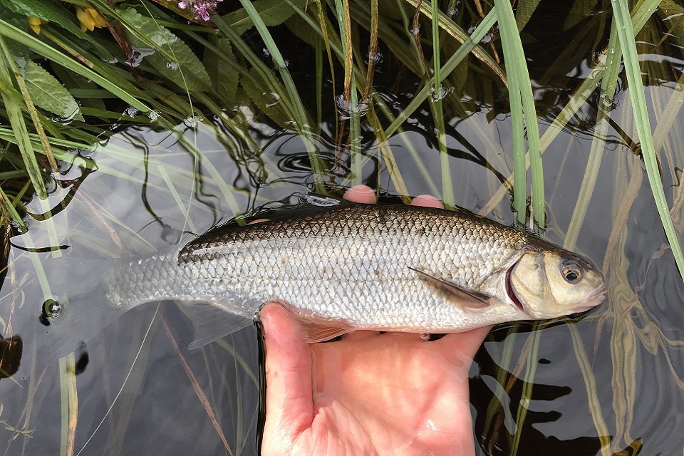
Image shows one of the dace caught in the survey

Surveys provide information

Hydrologist Rachel Merrix, who led on the trial for the Environment Agency, added:

Although the annual trial of the revised release regime ended last October we continue to monitor river flows and temperature to ensure that the environment is protected. Fish surveys such as this one provide us with additional information which increases our confidence that the revised releases are not having an adverse effect on native coarse fish.

We have had some feedback from both reservoir and river users on the impact of the releases but would encourage others to let us know if they have any concerns.

We continuously monitor river levels, flows and water temperatures at several locations in the Tyne catchment and all of this data is available on request.

Other activities to monitor the impact of the new Kielder release regime include temperature monitoring at 11 new sites, as well as electric fishing surveys for juvenile salmonoids and freshwater pearl mussel assessments.

For more information and updates on the trial visit the Kielder release website or email Kielder.reservoir@environment-agency.gov.uk with any queries or observations.


Press release: Fishing without a £30 licence costs angler £1000 in court

On Wednesday 8 August 2018, Matthew Holt, aged 26, of Hollington Crescent in Birmingham, was found guilty in his absence at Northampton Magistrates’ Court for using an unlicensed fishing rod and line at Mineral Lakes, Bedworth on 14 October 2017.

Holt was given a fine of £300 and ordered to pay trial costs of £800, plus a £30 victim surcharge, after appealing a previous fine of £220.

The case went to trial following an appeal by Holt after he was found guilty of fishing illegally on 14 October 2017. Holt claimed he had a fishing licence, but the court heard evidence from the Environment Agency that showed he was caught fishing with another angler. As the bailiff was taking details of the other angler, Holt hurriedly bought a licence online. The court agreed that Holt was found fishing before he had a licence and believed he would have continued to fish illegally if the bailiff had not arrived.

Andrew Eardley of the Environment Agency said:

An annual fishing licence costs just £30, yet a small number of anglers continue to flout the law and risk prosecution for fishing without a licence.

When buying a licence online it takes around 30 minutes to become active. It’s important anglers have a licence before fishing; the money from licences is invested into England’s fisheries and rivers; improving the sport of angling.

Environment Agency officers are out checking licences regularly throughout the year. A licence costs just £30 and lasts for 12 months from the day it is purchased.

Money from fishing licence sales is invested in England’s fisheries and is used to fund a wide range of projects to improve facilities for anglers including; protecting stocks from illegal fishing, pollution and disease, restoring fish stocks through re-stocking, eradicating invasive species and fish habitat improvements. Fishing licence money is also used to fund the Angling Trust to provide information about fishing, to encourage participation in the sport and to manage a voluntary bailiff scheme.

Children up to the age of 16 can fish for free, but do need to have a valid fishing licence. Anyone over 16 must pay for a licence to fish for salmon, trout, freshwater fish, smelt or eel in England.

Anyone witnessing illegal fishing can report it directly to the Environment Agency hotline, 0800 80 70 60. Information on illegal fishing and environmental crime can also be reported anonymously to Crime stoppers on 0800 555 111.


Press release: Progress continues on new North East fish pass

New fish pass ‘baffles’ to help fish get across a barrier in the River Wear have been installed this week in a significant step forward for the new Stanhope Fish Pass.

The Environment Agency resumed work on the fish pass in June after it was postponed in November due to health and safety concerns about high river levels, and to allow for fish to spawn.

The £260,000 project at Stanhope Weir includes a Larinier fish pass to open up the river and make it easier for salmon and sea trout to move up the River Wear to spawn.

Baffles are a series of metal plates which are fixed to a sloped concrete channel – they slow the flow of the water so that fish can swim over the top of them easily.

The Environment Agency is also carrying out repairs to the weir which will improve the river flow and level monitoring capability of the Stanhope River Gauging Station.

‘Significant step forward’

Daniel Magee Project Manager for the Environment Agency, said:

It’s a significant step forward for the new fish pass to see the baffles going in – this is going to make it so much easier for fish to reach their natural spawning grounds and is good news for the River Wear.

By also improving the monitoring capabilities of the gauging station we can continue to provide an accurate and timely flood warning service to around 400 homes at risk of flooding from the River Wear.

When the work is complete it safeguards the flood warning system for the future as well as creating environmental improvements. We appreciate the community’s continued patience while this work has been ongoing.

Stanhope Gauging Station is ranked in the top 10 most important flow sites in the North East area. Opened in September 1958 it has an almost continuous record of flow data, making it one of the longest flow records in the North East area at 60 years.

Work is expected to be completed by the end of this month.