Press release: Milestone for managing seas in South of England reached

The Government has now adopted England’s South Marine Plan, which brings a new approach to managing the seas between Kent and Devon.

The new marine plan provides a policy framework which will be used to help inform decision-making on what activities take place in the marine environment and where how the marine environment is developed, protected and improved in the next 20 years. It will inform and guide decisions by regulators managing the development of industry in marine and coastal areas, while conserving and enhancing the environment and recognising leisure uses.

The marine plan, produced by the Marine Management Organisation (MMO) on behalf of the Department for Environment, Food and Rural Affairs, is the culmination of around 5 years of engagement with business, charities, representative organisations and individuals.

The plan will help business realise the economic benefits available from the Marine Plan area whilst ensuring the marine environment remains protected. Covering an area of approximately 1,700 kilometres of coastline and over 21,000 square kilometres of sea, the plan stretches from Felixstowe in Kent to the River Dart in Devon. This is a very dynamic marine area incorporating 9 world heritage sites and some of the busiest shipping channels in Europe.

The MMO is now working with Local Authorities in the area to ensure successful implementation of the new Plan.

Environment Minister Thérèse Coffey said:

The South Marine Plan is a significant milestone in our ambition to create healthy and biologically diverse seas and oceans, as outlined in our 25 Year Environment Plan.

Stretching from Kent to Devon, this is one of the most complex areas of the English coast and this plan will allow us to safeguard our sea life while supporting a more sustainable marine economy.

John Tuckett, Chief Executive Officer at the Marine Management Organisation, said:

This is a significant milestone for one of the most complex and used areas of the English coastline.

The South Marine Plan will help ensure that when activities take place, they happen in the best location and in the right way within the marine environment. We are now working closely with decision makers and stakeholders along the coast to ensure that the Plan is understood and used effectively.

By 2021 all English marine area will have marine plans in place. The South Marine Plan is the second to be adopted following the introduction of the first English marine plan established in the East of England in 2014.
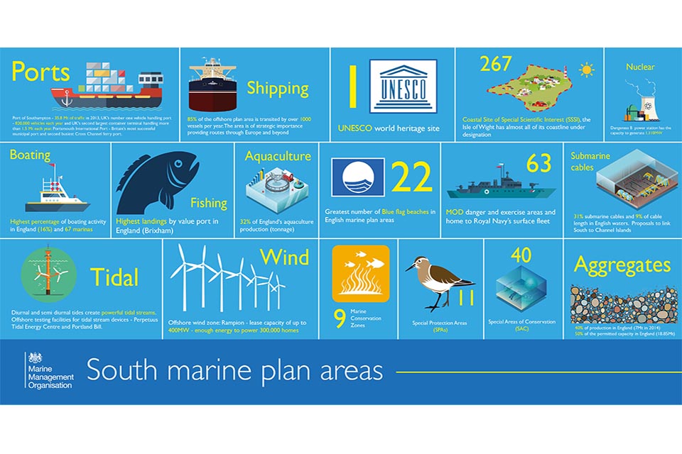
South marine plan infographic

Notes to editors

short animation film to explain marine planning

Further background on marine planning:

  • There are 11 English marine plan areas, including inshore and offshore areas. Work continues to produce plans for the South East, South West, North East and North West, the target for adoption of the remaining plans is before March 2021.
  • Marine planning addresses the key issues for the marine area, including the coast, estuaries and tidal waters, as well as developments that impact on these areas. The plans will include a vision, objectives and detailed policies on how these objectives will be achieved.
  • Marine plans are used by public authorities as part of the decision making process for all new activities and developments in or affecting the marine area.
  • Marine plans build on the requirements of the Marine and Coastal Access Act and the Marine Policy Statement.

More information on marine plans is available elsewhere on GOV.UK

How will marine plans be used?

The plan is brought into effect through its use in decision-making. All public bodies are legally required to make all authorisation and enforcement decisions which are likely to affect the marine areas in accordance with marine plans, unless an exception states otherwise.

Such decisions vary widely and include The Crown Estate leasing the seabed for renewable energy, Environment Agency permitting of flood and coastal defence works and water discharges, Local Planning Authorities (LPAs) determining planning permissions, to Inshore Fisheries and Conservation Authorities (IFCAs) making fisheries byelaws.

The MMO will implement the adopted marine plans across all decision-making functions, including:

  • Marine licensing
  • Marine compliance and enforcement
  • Fisheries management and effort control
  • European Fisheries Funding
  • Coastal operations

The MMO is working to support other relevant authorities to adopt/implement the South Marine Plan in their decision-making processes.

The plans aren’t an enforcement tool as such, more a policy framework for the future use of the sea. (It’s not a law change in that people aren’t being expected to change currently occurring activity to comply with the plan.)

Will the plans result in activities being banned?

The plans are not a list of prohibited activities, but a strategic vision for the sustainable use of shared marine environment seeking to maximise opportunity and encouraging co-existence between many differing marine activities.


Statutory guidance: The South Marine plans documents

Updated: Modification report added

Published July 2018 the South Inshore and South Offshore Marine Plan provides guidance for sustainable development from Folkstone in Kent to the River Dart in Devon.

Marine plans address the key issues for the area, setting a vision and objectives. Detailed policies set out how these will be achieved and how issues will be managed or mitigated. The policies inform decision-making for any activity or development which is in or impacts on a marine area.

Our Marine Information System (MIS) supports decision-makers and applicants using the South Marine Plan. It includes overview of each plan policy by sector and a searchable map of relating data and evidence.

In developing the South Inshore and Offshore Marine Plan we have also published:

  • habitats regulations assessment
  • sustainability appraisal
  • approach to monitoring
  • modification report

Marine plans place sustainability at the centre of all decisions.

The Sustainability Appraisal (SA) provides an independent assessment of economic, social and environmental sustainability.

Public consultation on the Draft South Marine Plan and Draft Technical Annex was held between the 7 November 2016 and the 27 January 2017.

Following this consultation in accordance with the Marine and Coastal Access Act (S15 (7)), the Marine Management Organisation (MMO) are required to publish statements detailing any modifications made to the consultation draft and the reasons for the modifications. The south plan areas Statement of Public Participation describes how the MMO will analyse all responses to the consultation and produce a summary report setting out comments received and changes made to the plans as a result.

The purpose of this document is to summarise:

  • engagement process on the consultation draft
  • responses received, provide an overview of the levels of agreement with the plans supporting sustainable development and compliance with the Statement of Public Participation
  • changes made from the consultation draft to the South Marine Plan and Technical Annex


Press release: Critical asset for early flood warning in York being built

The channel is being built in the river where it passes under the A59 at Skipbridge, Green Hammerton, between York and Harrogate.

Once the channel has been built an ultrasonic sensor will be attached under the bridge so accurate flow readings can be achieved.

This is important for predicting floods in York because the River Nidd is the last major watercourse flowing into the Ouse.

Project manager Oliver Wilson said:

This is one of the Environment Agency’s critical assets for our flood warning service and for managing water resource available for abstraction.

Having an early warning that the Ouse could overtop in York means we can act early to prevent flooding by closing flood gates in the city.

So that the concrete lined channel can be built a cofferdam has been put in place.

One half of the river is dammed off to create a dry working area to enable construction on that side, before the other side is dammed and the new channel structure can be completed.

There was an existing concrete channel built a number of years ago but due to the design and flow dynamics it created in the river the bed got silted up, causing incorrect flow readings and it not working as an effective gauge station.

The new channel is designed to make sure sediment passes through it and flow readings are accurate.

Mr Wilson added:

Lower river levels have enabled us to make really good progress and we expect the gauge station to be fully functioning this winter.

North Yorkshire County Council’s Highways Department has carried out work on the bridge and road earlier this year and Northern Powergrid also recently installed an electricity line across the bridge.

To view river levels click here


Press release: Commonwealth countries unite to tackle ocean plastic pollution

Four more countries have signed up to UK and Vanuatu-led efforts to tackle ocean plastic, announced Environment Minister Thérèse Coffey today as she hosted the first meeting of the Commonwealth Clean Oceans Alliance (CCOA).

The Alliance, which was announced by the Prime Minister during the Commonwealth Heads of Government Meeting in London (16-18 April), aims to unite countries around the Commonwealth so they can work together to turn the tide on plastic entering the marine environment. It sees each country pledging to take action – be this by a ban on microbeads, a commitment to cutting down on single use plastic bags, or other steps to eliminate avoidable plastic waste.

Three months on, Australia, Fiji, Kenya and St Lucia have now formally joined the Alliance and will sit alongside New Zealand, Sri Lanka and Ghana to create a nine-strong coalition in the fight against plastic pollution.

High Commissioners from over 30 Commonwealth countries, including Tanzania and Nigeria who have not formally signed up to the Alliance, met in London today to share the ambitions and expertise they have and reiterate their commitment to healthy oceans.

The meeting was chaired by Environment Minister Thérèse Coffey where she highlighted the UK’s global leadership on ocean conservation and updated on action taken under our 25 Year Environment Plan.

Environment Minister Thérèse Coffey said:

Marine plastics pollution is one of the greatest environmental challenges facing the world today, requiring a truly global approach to developing a solution.

By joining together the expertise and ambitions of the Commonwealth countries, we can make huge strides towards eliminating all single use plastic from our oceans. I thoroughly enjoyed hearing from other countries on how they are approaching this challenge, and look forward to seeing what difference we can make together.

Minster Coffey also outlined the assistance available from the UK to support Commonwealth countries through the £61.4million Commonwealth Oceans Plastic Package, as announced by the Prime Minister at the Commonwealth Heads of Government Meeting in London earlier this year.

Included in the package is a £25million Marine Plastics Research and Innovation Framework, to help researchers approach the scourge of marine plastic waste from a scientific, technical, economic and social perspective.

More details were also revealed about the Global Plastics Action Partnership, a Defra-funded £2.4million project linked to CCOA to tackle global plastic pollution in rivers, deltas and oceans. Three initial projects will be launched as part of the public-private project in hotspots around the world; in Southeast Asia, West Africa and a Small Island Developing State.

The UK Government continues to lead the way in tackling plastic, with one of the world’s strongest bans on microbeads introduced last month and 9 billion fewer bags distributed thanks to the 5p plastic bag charge. Environment Secretary Michael Gove has also outlined ambitious plans to end the sale of plastic straws, stirrers and cotton buds and introduce a deposit return scheme, subject to consultation.